The 2nd touchdown operation will take place from July 9 – 11. Here, we describe the operation events and schedule (the operation is referred to as the “2nd touchdown” but denoted PPTD).
For discussion about the 2nd touchdown operation, please take a look at these recent articles on our website.
(1) Approach to the 2nd touchdown –Part 1: observations near the touchdown point−
(2) Approach to the 2nd touchdown –Part 2: details of the touchdown point−
(3) Approach to the 2nd touchdown –Part 3: to go, or not to go−
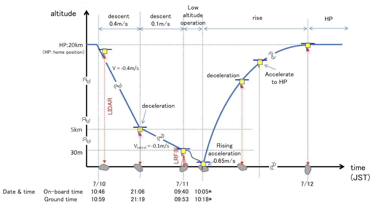
The first shift for the 2nd touchdown starts on July 9, where the set-up for the descent will be completed. The actual descent will begin on July 10 at 10:46 JST (on-board time). Initially, the descent will begin at a velocity of 40cm/s, matching that in previous operations. At 21:06 JST, the altitude will reach about 5km, whereupon the descent will slow to about 10 cm/s. On July 11 at 09:40 JST, the altitude will have reduced to 30m and the spacecraft will start to hover. Touchdown will be at about 10:05 JST at the earliest, and about 10:45 JST at the latest. Immediately after touchdown, the spacecraft will rise at a speed of about 65 cm/s and return to the home position on July 12. The entire touchdown operation is shown in Figure 1.
-
[Open in a separate window]
Figure 1: Outline of the 2nd touchdown operation. The switch to using the Laser Range Finder (LRF) will take place during the descent from 30m. The time of touchdown indicated with the * is estimated to be around 10:05 JST (onboard time) at the earliest and about 10:45 JST at the latest (image credit: JAXA).
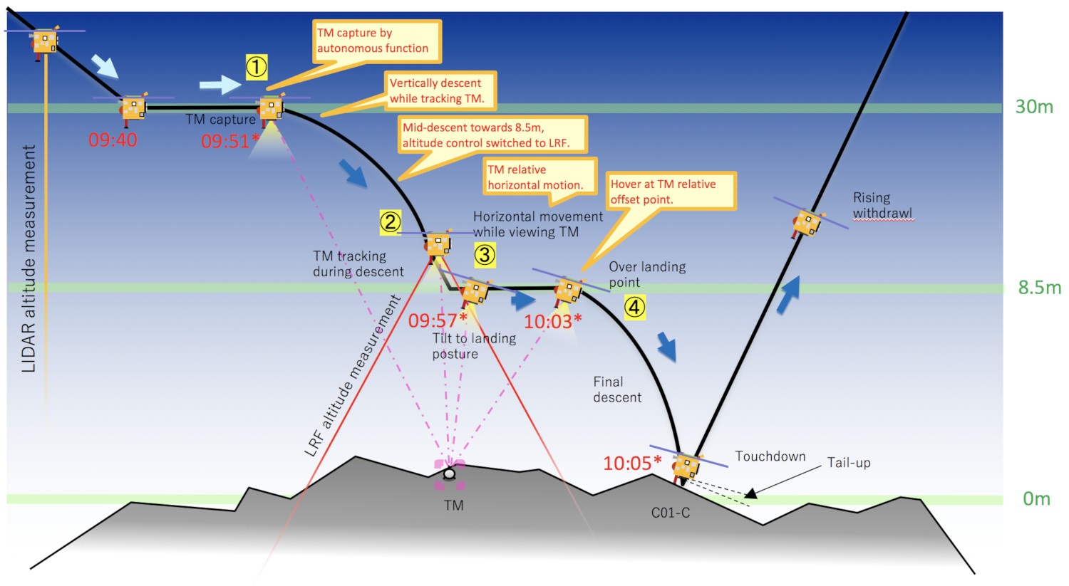
Figure 2 shows the operation at low altitude in detail. When the altitude reaches 30m on July 11 at 09:40 JST, the spacecraft will hover and capture the position of the target marker. This is done autonomously, so we do not know in advance when the target marker will be captured but if this is about 09:51, then the spacecraft will start to descend immediately. At this point, the altitude is being measured by the laser altimeter (LIDAR) but during this next descent, the task will be taken over by the Laser Range Finder (LRF). The spacecraft will then descend while keeping the target marker in the center of the field of view. At 09:57 JST, the spacecraft will reach an altitude of 8.5m and begin to hover again.
-
[Open in a separate window]
Figure 2: Operation sequence at low altitude.
From an altitude of 8.5m to touchdown, the spacecraft will follow a parabolic trajectory as it descends due to the pull from Ryugu, but will appear to descend almost directly downwards as viewed from the asteroid surface. The times indicated by the asterisk * are an example for the case where the operation proceeds at the fastest time and the actual time could be delayed by up to about 40 minutes. (Image credit: JAXA)
After hovering at an altitude of 8.5, the first step is to change the attitude of the spacecraft to the landing attitude. The landing attitude is basically an attitude parallel to the surface of the asteroid but –as with the first touchdown—the attitude is slightly raised on the ion engine side (opposite the sample capsule) of the spacecraft. In the project team, we refer to this as a ‘tail-up’ posture. Changing the attitude would cause the target marker to move towards the edge of the field of view, but the spacecraft moves horizontally while changing attitude to keep the target marker centralized. After the attitude change, the spacecraft moves further horizontally to directly above the center of the touchdown point. And, when all conditions are satisfied, the spacecraft starts to descend at 10:03 JST, reaching the surface at 10:05 JST, completes the touchdown and immediately begins to rise.
However, please remember that the times for altitudes of 30m or less described in Figure 2 and the above description are for an example case where the spacecraft operation progresses most swiftly. When the 30m altitude is reaches, the spacecraft will operate autonomously. As the spacecraft will check each operation before proceeding, the time needed may be longer. This is why the touchdown time is about 10:05 JST at the earliest but could be as late as about 10:45 JST. The same is true for the other times listed, which may be up to 40 minutes behind the times given here.
Figure 3 shows an animation of the movement of the spacecraft from an altitude of 8.5m to touchdown.
-
[Open in a separate window (mp4, 3.7MB) ] Figure 3: Motion of the spacecraft from an altitude of 8.5m to touchdown (16x speed). The green circle is the touchdown area, C01-Cb. The lower right image shows the area that falls within the field of view for the Optical Navigation Camera – Wide angle (ONC-W1). (Image credit: JAXA)
The touchdown location was named by the project team as C01-Cb. Please take a look at article (2) for details about this site. Figure 4 shows an animation of the Digital Elevation Map (DEM), which is a three-dimensional diagram of the surface near the touchdown point. Although C01-Cb is relatively flat, it can be seen that there are still large boulders around the site.
-
[Open in a separate window (mp4, 5.6MB) ] Figure 4: Animation of the DEM (Digital Elevation Map) near the second touchdown point. (Image credit※1: JAXA, University of Tokyo, Kochi University, Rikkyo University, Nagoya University, Chiba Institute of Technology, Meiji University, University of Aizu, AIST, Kobe University, University of Occupational and Environmental Health.)
The 2nd touchdown is the last big operation at Ryugu for the Hayabusa2 project. We will proceed with caution and the upmost care. Please wish us success…!
Hayabusa2 Project
2019.07.10
※ Please use the displayed credit when reproducing these images..
※1 If an abbreviated form is needed, please write "JAXA, University of Tokyo & collaborators".