Note: This article was originally published in Japanese on the website of the National Astronomical Observatory of Japan (NAOJ) Research of Interior Structure and Evolution of Solar System bodies (RISE) group. (Submitted on Aug. 2, 2018)
Approximately one month has passed since the laser altimeter (LIDAR) onboard Hayabusa2 measured the distance to asteroid Ryugu for the first time. The figure below shows the analysis of the data acquired during this period, with each point showing where the laser reflected from the surface of Ryugu. Normally, the attitude of the spacecraft is controlled so that that the laser altimeter faces the equator. But during this operation, the attitude was changed to move along the asteroid’s axis of rotation; this is an “attitude scan” that has been performed twice so far. In the vicinity of the poles, there are currently fewer data points, but you can see the global shape of Ryugu.
In order to construct this shape, the orbit of the spacecraft must be accurately predicted. The accuracy is currently several hundred meters. That the position of a spacecraft 300 million km away from Earth can be determined to within hundreds of meters is impressive, but this error is still too big to describe the shape of the 900m diameter Ryugu [*]. We are therefore improving the trajectory of the spacecraft using the distance measurement data from the laser altimeter. The improved orbital data of the spacecraft also aids the other equipment teams on Hayabusa2 and is being used to select the best landing site.
Koji Matsumoto (NAOJ)
[*] To create the figure below from the LIDAR data, we used the shape model of Ryugu to guide the three-dimensional structure.
-
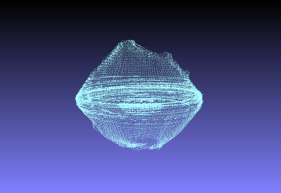
[Enlargement] (Image credit: National Astronomical Observatory of Japan (NAOJ), JAXA, Chiba Institute of Technology, University of Aizu, Nihon University, Osaka University).
Hayabusa2 project
2018.10.26