The BOX-B operation ran between August 18 and September 7. Here, we explore the images taken from BOX-B.
Hayabusa2 usually stays at the home position, about 20 km from Ryugu. The direction of the spacecraft is also fixed as the home position for Hayabusa2 is situated on the line connecting Ryugu and the Earth. During this exploration period, the Earth and Sun could be seen in almost the same direction from view point of Ryugu. That meant that if the spacecraft were to stay at the home position, Ryugu would appear similar to an almost full moon. This is convenient as almost all of Ryugu is illuminated, but it is important to observe the asteroid not only from the front but also from diagonal directions. To achieve these different viewing angles, we initiated the BOX-B operation.
A schematic of the BOX-B operation is shown in Figure 1. The spacecraft started from the home position on August 18, initially moving north of the ecliptic plane to reach 9 km on August 24. Hayabusa2 remained at this new location for about one day. From there, it was easier to observe the south pole side of Ryugu (the asteroid rotates in the opposite direction to the Earth, so the Earth’s north pole is Ryugu’s south pole). Hayabusa2 then moved diagonally, moving to a position on August 31 where the evening side of Ryugu was easy to see. After spending one day in this location, the spacecraft returned to the original home position on September 7. This was the BOX-B operation. As the observations were gathering during this travel, we sometimes also refer to this as the “observation tour”.
-
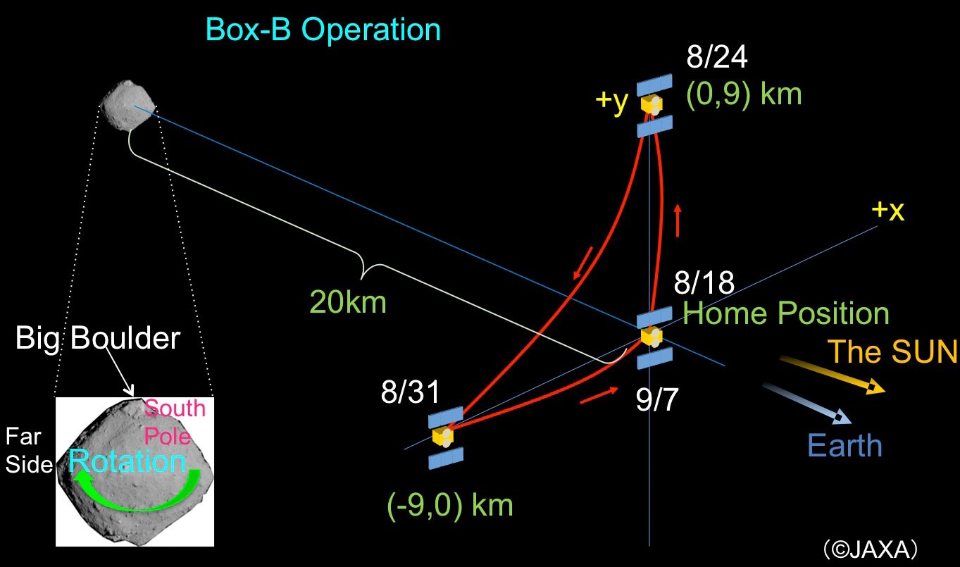
[Enlargement] Figure 1: Outline of the BOX-B operation. (Figure credit: JAXA)
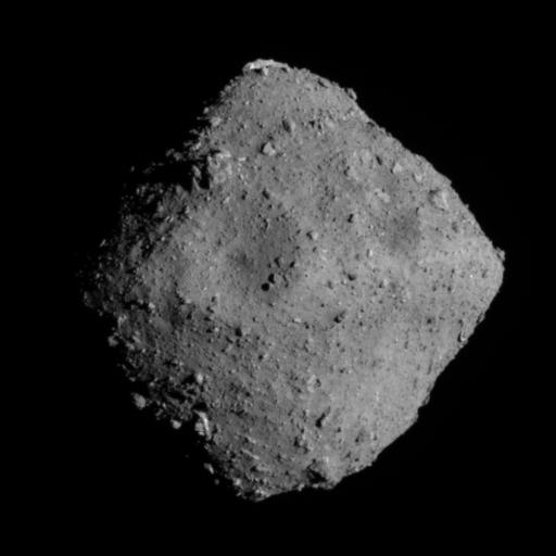
Here we take a look at the images taken during the BOX-B operation. First is Figure 2, which shows an image of the south pole side of Ryugu. There is a large boulder near the south pole, and if we include the smaller rock masses as well, we can see that the vicinity of the south pole is also covered with boulders.
-
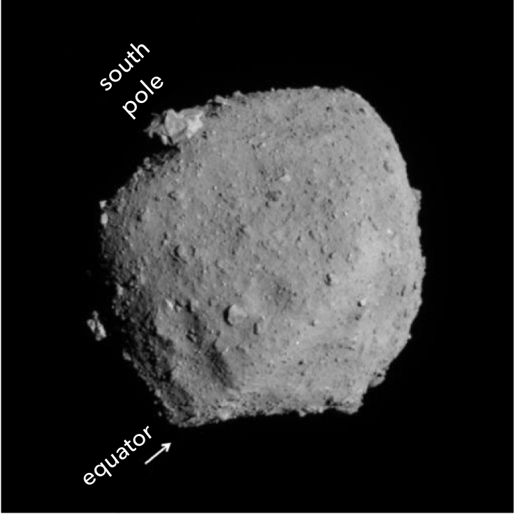
[Enlargement] Figure 2: Image of Ryugu towards the asteroid’s south pole. Photograph taken with the Optical Navigation Camera Telescopic (ONC-T) on August 24, 2018 at around 17:00 JST. The image was captured from a position of around +y = 9 km. The distance to Ryugu was about 22 km.
(Image credit ※1: JAXA, University of Tokyo, Kochi University, Rikkyo University, Nagoya University, Chiba Institute of Technology, Meiji University, University of Aizu, AIST)
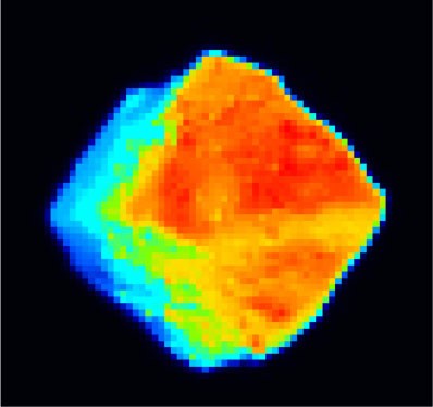
These next images show the evening side of Ryugu. Figures 3 and 4 show the images captured by the Optical Navigation Camera Telescopic (ONC-T) side-by-side the image taken with the Thermal Infrared Imager (TIR).
-
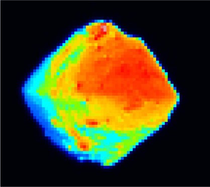
[Enlargement (left)] [Enlargement (right)] Figure 3: Images taken in the evening direction of Ryugu. Left is the photograph with the Optical Navigation Camera Telescopic (ONC-T) and on the right is the photograph from the Thermal Infrared Imager (TIR). The photographs were taken on August 31, 2018 at around 19:00 JST from a position of around -x = 9km.
(Left image credit ※1:JAXA, University of Tokyo, Kochi University, Rikkyo University, Nagoya University, Chiba Institute of Technology, Meiji University, University of Aizu, AIST; Right image credit ※2: JAXA, Ashikaga University, Rikkyo University, Chiba Institute of Technology, University of Aizu, Hokkaido University of Education, Hokkaido Kitami Hokuto High School, AIST, National Institute for Environmental Studies, University of Tokyo, German Aerospace Center (DLR), Max Planck Society for the Advancement of Science, Stirling University.)
-
[Enlargement (left)] [Enlargement (right)] Figure 4: Images taken in the evening direction of Ryugu. Left is the photograph with the Optical Navigation Camera Telescopic (ONC-T) and on the right is the photograph from the Thermal Infrared Imager (TIR). The photographs were taken on August 31, 2018 at around 23:00 JST from a position of around -x = 9km.
(Left image credit ※1:JAXA, University of Tokyo, Kochi University, Rikkyo University, Nagoya University, Chiba Institute of Technology, Meiji University, University of Aizu, AIST; Right image credit ※2: JAXA, Ashikaga University, Rikkyo University, Chiba Institute of Technology, University of Aizu, Hokkaido University of Education, Hokkaido Kitami Hokuto High School, AIST, National Institute for Environmental Studies, University of Tokyo, German Aerospace Center (DLR), Max Planck Society for the Advancement of Science, Stirling University.)
On the left-hand side of the ONC-T image, you can clearly see the shadows from the asteroid’s bumpy surface where the Sun is setting. Comparing the far-left side with the TIR infrared image, you can also see that the ONC-T frame includes a region on the nightside of Ryugu from which no light was reflected. The TIR image indicates high temperature regions in red and low temperature regions in blue, from which it can be easily seen that the temperature drops on the night side of Ryugu. Evening observations like this one allow us to understand the appearance of the irregular surface features as well as the changes in temperature the asteroid experiences.
In this BOX-B operation, we observed the south side and evening side of Ryugu. The reason for observing the south side was to investigate the large boulder in detail. The evening side was observed as it was an easy to reach during this operation of the spacecraft. Additionally, as the region observed covered noon through to night, it was a good opportunity to investigate the drop in temperature. The next BOX-B operation is not currently scheduled, but a good candidate for the future observation tour would be the north pole side and the dawn side of Ryugu.
Reference: For details on the BOX, please refer to this article.
※ Please use the displayed credit when reproducing these images. In the case where an abbreviated form is necessary, please write ※1 "JAXA, University of Tokyo & collaborators" and ※2 “JAXA, Ashikaga University & collaborators”.
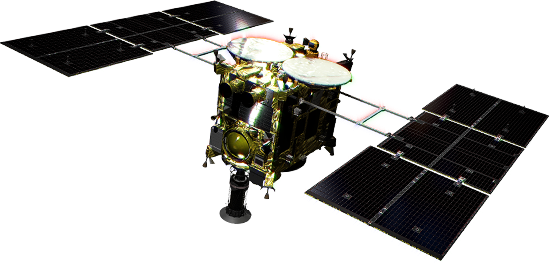
Hayabusa2 project
2018.09.27